Sunday, April 21, 2024

Annual summer early fall climate weather projection, by unorthodox means, the one and only place that does so, with actual database.

~Summer 2024 is already baked hot

~Slow transition to La-Nina, there still persists a surplus of Arctic clouds

~2016-2024 remarkably similar, suggesting a 2016 summer 

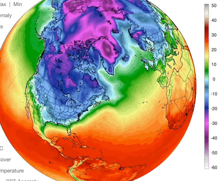
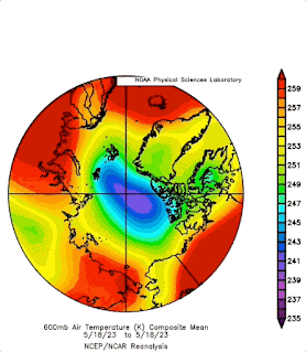
~ Вот это да! Cold Temperature North Pole was more Siberian Russian


WHAT is the score?  Vertical sun disk differential refraction results.


The most potent forecast tool in the world, number of average maximum vertical sun disks, at decimal elevation from 0 to 10 degrees, confirm there is an El-Nino, might seem a ridiculous statement,

but all measurements were done 4476 nautical miles from the equator, keep that in mind.


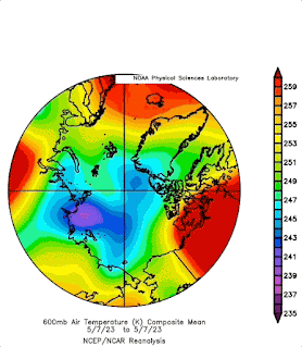
Astounding Results, La-Nina’s or La-Nina type seasons rank in the bottom , El-Nino’s or close to El-Nino peaks rank in the top, strong sea ice melts rank in the middle, such as 2021,2016, 2012 and 2007.  Sea ice will be dealt with later, it is not so simple, all the while of these years sea ice has been progressively thinning, it is no longer comparable without injecting this fact.   2024 had #1 ranking for the longest time during this cloudy observation period, gradually as the sun sets further North, vertical sun disk diameter measurements get smaller, because sun rays penetrate the true cold Polar airmass Northwards of 270 degrees azimuth.  This year was no exception, but there were a few records North of 270 degrees, it was amazing. I expected the Cold Temperature North Pole centre to nearly always show record shrunken sun disk diameters North of 270, as was with previous recent years.  But that was not the case. CTNP was mainly in Russia, self driven away by onslaught of record warm North American temperatures, which were in no small part driven by Polar Vortex morphology.  Data from 355 vertical sun disks observations, each one having huge potential in measuring the temperature of the entire atmosphere, like placing thousands of thermometers in line towards the sun all the way to space.  The Southwards sun disks, almost all of them, were near record or surpassing record measurements.  Of each individual elevation degree levels, from 0 to 10 degrees,  9 were 0.1 minutes or more (minutes of arc) above average of 2006 to 2021, however all 2024 individual degree averages were above years 06 to 21.  We note 2018,19,20,22 and 23, all years mainly taken at or near centre of CTNP, making the bottom of the rankings, 2024 marks a significant shift in weather patterns, wherever you are in the Northern Hemisphere, expect different weather, which in some parts of the world is good, in other areas which benefited recent years good summer weather, sorry for the change.  In retrospect 2021, 2006, 2005 and 2009 all had spring time ENSO warming.  Which leads to an interesting posit; are ENSO and the Polar regions CTNP’s placement interlocked?  Does one need the other to reappear?


Sunsets


Round is the word, for most sunsets such as this one March 11 2024, very tame , lame, no refraction miracles.  


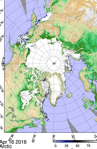
      The entire sunset season was defined by excessive clouds, as one might have during a strong El-Nino period.  The sea ice also formed late in the fall of 2023, under mostly cloud covered skies, meaning ice did not accrete as much as usual, this thinnest guarantees weaker inversions.  When the sun reappears during the long night, it warms the sea surface more, and the thermal sea ice rebound is less immediate with thinner ice, in other words, the creation of 

thermal layers is more gradual, therefore less horizon sky anomalies.  Skimming from the few sunsets gathered were mostly Southwards, thus shorter spring days by the mere warming of the Arctic. 


First underwater sea ice interface melt


   First melt occurs when a thermal balance is obtained by solar for forcing, when the bottom of sea ice starts melting.  The thicker the sea ice the greater sunshine is needed. This melting is temporary, still allowing

over all daily accretion eventually bottom melting last hours until melting exceeds accretion, then the ice starts breaking apart.  2024 winter had primarily no snow on the surface, a benefit for sea ice accretion, 

if the low snow cover remains in the spring, it is detrimental for accretion. This years first melt occurred March 16,  one

of the lowest on record, but it snowed a lot more after that date,  thus sparing a continuance of longer under sea ice melting.  As a consequence of this spring gained  more normal snow cover, It took nearly a month for bottom melting 

to resume on April 11.  Although the bottom melting has stopped for a while, ice accretion of course lessened, because of thicker snow insulation,  it was likely a zero sum gain for sea ice thickness.  But indeed an illusion for the larger total 

 sea ice extent it may give as viewed from space.  If this snow cover gain spread throughout the Arctic, I don’t see why not, because of the Atlantic and Pacific moist air dominance, bearing more clouds and snow, this was equally seen with

polar orbiting satellites as some Arctic basin leads, in particular vast areas with thinner sea ice changed colour from grey to white.  The over all sea ice extent may appear larger, but eventually will foster  more melt ponds, over thinner ice,  a catastrophic situation only to be averted by excess cloud cover, which is not foreseen, as El-Nino peak is waning.   


This Concludes the in situ synopsis, next is the over all consequences to be learned from this analysis based on key data. WD April 21, 2024

Friday, April 19, 2024

With less clouds near land, Arctic sea ice shrink

 ~Comparison 2016-2024 El-Nino to El-Nino

~Less cloud factor spells potential doom with current Arctic Sea ice thinned state


There is always less clouds on the East continental coasts when (West to East) air skims over long distance land as opposed to sea. On the East coasts of Asia and America 2024 JAXA sea ice is almost vanished, while comparing sea ice extent between El-Nino winters 2024 Vs 2016 which was the last major El-Nino year. We have here clear example of current state of sea ice, it is overall thinner, therefore melts easier with more sun (less clouds).  This means that 2024 sea ice melt will be remarkably vulnerable from more sunshine.   Unfortunately it seems the worse case scenario for sea ice is unfolding, years of thinning ever so slowly, in a precarious state, it might be facing a La-Nina late summer and fall, over all fewer clouds, because of the cloud seeding effect (a theory of mine), during El-Nino there is more clouds world wide, therefore a warmer winter.  When morphing to a La-Nina summer, it makes for a super hot summer, because winter didn't freeze the world as much as it could, and there will be less albedo sun ray reflecting clouds.  Hence guaranteeing a very low sea ice extent Minima come September 2024.   


As predicted, the greater the warming of the planetary atmosphere the smaller but colder the center of the Polar Vortex will be,  spring 2024 NOAA composites of 2016 vs 2024 proves the idea. the shrinking of the cold zone made continental East Coast sea ice vulnerable to a much warmed winter land surface.
We note:  Siberia had the colder spring and most so during winter, henceforth sea ice footprint is made. 
North American Polar ice is set to take a further appearance of melting, but it really is because it never accreted as much as normal (like 2012). Note the Californian coast of 2024 having more an onslaught of the jet stream, hence more moisture, hopefully smothering wildfires for a while to come.   WD April 19, 2024 

Tuesday, March 5, 2024

Unprecedented Kara sea ice retreat at Novaya Zemlya, when winter cold should reign supreme.

 ~At least since 2004,  which highly likely means since historical records began.  

~Whilst 2024 maxima hovers about 14 million square Kilometers , right near the lowest extent ever.

University Bremen AMSR2 sea ice concentration  February 24 to March 4 2024:


Now March 4's 2004 to 2024,  2024 is the only one with water South of Novaya Zemlya Island,  at or near Maxima extent,  a fast retreat in the works.  Likely by the nature of sea ice in the sea of Kara,  thinner,  weaker,  not what it use to be not very long ago, not able to survive warmer weather of late.   Early days 2024 already suggest a record year of sea ice events.  WD March 5, 2024

Sunday, February 18, 2024

NW Canadian Arctic archipelago littoral thin ice surviving tidal ridging, one more never seen before event

 ~As a result of overall thinner sea ice combined with lesser extent at minima,  the Archipelago coast has a new look

~A totally new Arctic Ocean feature, an introduction to the future shape of winter sea ice to come.


January 9 2023,  a polarview not unlike preceding years, perhaps with some thinner ice compared to the 80's, ridging near the coast can be clearly seen along with tidal frozen shore leads.  The Islands of the arhipelago, have different topography,  Borden Island (top left), Elef Ringnes 2nd from left,  Meighen Island is the little one next to mountainous  Fjord rich Axel Heiberg extreme right.

Impossible scenery December 23 2023.  there is a wide open area of very thin sea ice all along the same coast.  Not a fierce storm temporary feature.  Thin "black" ice was there for quite some time. It was predicted that the coast would be freer seai ice at minima,  this new sea ice was likely frozen in place sometimes in October.   

Very peculiar new sea ice,  never  seen so wide offshore lasting very long.


 Lasting the entire month of Januar 2024.  Remarkable,  in the past, Arctic Ocean sea ice would have crushed this newer thinner shore sea ice in a matter of days.

A closer look loop of January 23 to February 16 2024, reveals the tidal breaking of all ice, new and old, moving in unison in the direction of the Arctic Ocean tidal gyre.  There were several breaks similar to this. Thinner sea ice would break easier.  However, the lack of ridging seems permanent,  indicating a significant change in sea ice dynamics, this is quite unfamiliar, of course expected when the icescape features are fundamentally very different in overall thickness along with major weather pattern changes. WD February 18, 2024 


Thursday, February 15, 2024

Warm 2023-2024 Worldwide shrinking of winter

 ~600 mb pressure level closely indicates the temperature of the entire atmosphere

~ Current warming undeniably has changed weather patterns everywhere, strange or rare events are normal and common

~In essence, predicting long range weather will be even more difficult because we never been this warmed.  Forecasting chaos is a safer bet.  


GONE is thick sea ice driven cooling over the Arctic ocean,  equally giving no Cold Temperature North Pole at the North Pole, as once was not so long ago.  NEW patterns are a plenty;  NEW by-Polar CTNP's over the continents,  NEW deep warming incursions over the Arctic Ocean, NEW shrinking of the entire winter Zone for the Northern Hemisphere, finally CTNP's can dominate on one continent only, leaving the other with hibernating bees waking up mid winter.  It is now quite foreseeable to visualize the future of winter with a much warmer Arctic Ocean zone cutting off the buildup of strong by-continental anticyclones shivering most of the world.  

     Next few months cooling and likely less of it will determine the coming weather for summer and fall. At present sea ice survives because of clouds, less coverage emperils the white cooling cap of the Polar North. Earth cooling system is hanging by a veil of fine water droplets and ice crystals along with a much thinner sea ice cover. Lets hope Polar clouds keep on reflecting sun rays to space,  otherwise more weather chaos will ensue.  Cloud are vey difficult to predict when moisture in Earth's atmosphere is on a world wide increase.  The tipping point will occur when air temperatures reduce the formation of strati clouds,  from there the end of summer sea ice will be,  from that point winter will be split in two smaller areas. WD February 15 2024   


Wednesday, January 17, 2024

+2 degree world diminutive Polar Vortex, stretched South, not because it was colder in the Arctic.

 ~Latest North American Polar Vortex was preceded by a huge North Pacific cyclone, effectively lowering Southwards the jet stream range.

~ Mild winter show of 2023-24 just had a Polar Vortex interruption which should be short lived,  because the Northern Hemisphere winter build up is very small.

    I think the weather medias are having a better understanding of the Polar Vortex phenom,  excellent,  but still don't understand how it is created,  how it behaves,  and especially where the cold air comes from in the first place. Cold air can be created South of the Arctic just as much as in the Arctic.  All is required is clear air at night, a low sun during the day and snow on the ground.  What makes the vortex apparently move are these 3 factors,  it is not created by the Arctic atmosphere.  If you know Earth Geodesy,  the Arctic is a far smaller region than further South,  it can't account for all the cold  covering much bigger land areas many times its size.  Broadcasted like "Arctic dome,  Arctic blast" is misleading.  What really happened of late is a huge North Pacific cyclone moved towards Alaska, this squeezed the small vortex buildup further South Eastwards,  which onto itself built step by step cooling Southwards (inducing High pressure genesis).  This is what most TV weather presenters call the Arctic blast,  but this cold is homegrown, literally over your head. The sun altitude below 30 degree elevation at noon is rather weak,  so Austin Texas,  with current 38 degree sun elevation at noon,  is not a bastion of heat,  has the sun below 30 degrees elevation for most of the day, but is basically at the last step in this Southward cooling process,  until the physical conditions that created this deep freezing disappear, like a nice warm breeze from the Gulf of Mexico.  The susceptibility of the smaller Polar Vortex to be morphed, and therefore cause the stepping process has been documented right here on several occasions,  when a place like Michigan has had the coldest air of the winter, colder than the Arctic, Siberia etc.    


U of Maine Climate Analyzer,   17 January 2024.  What appears to be very cold, is not, the small Arctic has a huge warming anomaly (white Globe),  while Arctic surface temperatures are still colder than most of the USA (reddish Globe),  so much for an Arctic blast . Extreme cooling is a normal winter process especially when a High pressure system sluggishly moves Eastwards. However 15 C Arctic warming anomaly is not normal when not just one day event,  most of the Arctic winter so far has been extraordinarily warmer.  Again warmest ever,  a decades old song that just cant stop repeating itself.  WD January 17 2024


Thursday, November 30, 2023

Warming a bit masked by sea ice extent minima numbers. Summer clouds from Global Warming excess moisture is saving Arctic sea ice from completely melting every year.

 ~EH2r April sea ice projection morphology was bang on

~Extent numericals slightly off,  again by underestimating  cloud effects.

~Hudson Bay early December sea ice in dire straits.  

    April 2023 sea ice minima extent projection:

Was very good.   


     Estimating sea ice morphology forecast breakthrough.  How does one see it coming to be when there was so much ice cover in April?  By finding out where the CTNP was located  all winter.  Cold Temperature North Pole winter 2022 2023  was peculiar.  But severely studying its gyrations gave this remarkable success.  However extent numbers were off by not so much,  sea ice extent forecasting is much more easier to do than a few years prior though. The problem was the obsession with 2012 and  2007 minima's,  which likely had more sunshine than all the other years, caused by combination of ENSO strengths and CTNP locations.  Which is still the case,  ENSO variant is particularly important.   The more clouds covers Arctic summer the less sea ice melts.  In particular 2007 had a great low albedo period,   2012 was a bit more complex,  with a particularly warm Arctic spring,  a CTNP geographical effect.    Since then sea ice thickness shrank, gradually,  with apparent moderation from greater cloud cover,   mainly from the great North Pacific warm sea surface blob.  

   Indeed,  Arctic sea ice can vanish almost completely given an extensive period  of low cloud cover,   The only way this can be done,  would be by massive summer La- Nina,   recent ones  has had a hard time exceeding the moisture coming from the warm Pacific blob.   It is a reprieve of sorts from yearly rapid sea ice extinction,  however the gradual melt down continues unabated,  heat from the surrounding massive oceans will eventually warm the Arctic Atmosphere causing less clouds.  And cause what is already happening in some key areas,  Hudson Bay being one of them:


Hudson Bay sea ice is more vulnerable because it is surrounded by land.  which dries out some of the North Pacific and Atlantic moisture giving clouds.  Now its virtually ice free when it should not be,  likely from prolonged summer insolation warming . WD November 30,  2023

Thursday, July 13, 2023

This July STEADY to STOP weather was foreseen in April

 ~Remarkable prediction success,  the new world weather order is here to stay.

   OK ,  back in April  ,    July projection:


July 13, 2023:

    "Historic heat streak"  was twinned with historic flooding particularly in Vermont USA.  EH2r April projection was written:  

                                  "With steady stagnating weather over North America, where its hot will persist hot,  where its moist will be soggier longer."


     The larger picture is clear, July 13 CMC loop shows no apparent or slow circulation:  

In fact it can be argued that the circulation has stopped in some parts :

Look at the mouse cursor pointing at Hudson Bay Low over one day,  literally not moving,  amongst other weather features,  but of course around any cyclone there is movement.  But when the cyclone stops moving,  the larger  general circulation is stagnant with respect to weather systems,  this gives troubling weather at any time of the year...  

     And so,  Global Anthropogenic enhanced Warming,  gives this kind of summer weather.  Being able to predict this feature,  was largely because the subject was observed many times,  the mechanics was finally uncovered in large part because climate scientists accepted GAeW as a fact,  they have taught this subject as best they could,  and to prove this good understanding, the projection or forecast,  from a humble student,  had to come through .   Anyone who does not dwell in this respected field,  who makes stupid claims that GAeW is not happening has naturally failed to predict anything correctly ad nauseam, should be shunned.  WD July 13, 2023


Thursday, May 25, 2023

EQUILIBRIUM , new horizon refraction discovery of what happens when Ti***=Tl***

 ~When heat radiation balance of Arctic lands  equals Sea ice ,  something extraordinary happens.  

~The Northern Hemisphere general circulation radically changes.  

    Whilst doing optical refraction research,  I discovered a thermal balance horizon image,   horizontal refraction between land covered by snow Tl***,  was the same as horizontal refraction of sea ice covered by snow Ti***,  on May17-18 this happened.  I realized that this was an important moment,  when the radiation balance of the entire Arctic became in equilibrium.  Thus,  there was no longer competing zones with the coldest air in the Arctic,  the Cold Temperature North Pole,  CTNP.  But rather a Pole centric CTNP.  Instead of 2 CTNP's on each continent there became only one.

                                                                                                       From May 7 to 17 the 600 mb coldest temperatures fractured the world with planetary waves  right above,
the 2 CTNP's looked very much like Galaxy simulations about to merge.  But the weather further South was perturbed by these waves,  hence General Circulation flowed or surfed the waves.    Which meant that in some zones ,  the weather appeared quite stable.   All this changed on the 17th,  where upon it is likely that the entire Arctic energy balance was more steady,  no more was land surface colder than sea ice .  Being equal means a consolidation of weather patterns.  The North Pole is coldest now,  because that is where the least sun radiation reaches the surface,  the Arctic continents have warmed to the point where they have lost the ability to generate deep cooling.


May 18 onwards , left,  600 mb represents the Density Weighted Temperature of the entire troposphere,  at least it is the closest standard level to it.  Here we see the North Pole centric nature of a single CTNP.  This brings about a much more fluid weather circulation pattern Southwards,  with planetary waves far less spread out,  otherwise if longer causing such weather phenomena as "Omega Blocks"  .  This less mega wavy geometry has coincided with the land and sea ice horizon refraction being equal,  for many days since the 17th . Near North Pole weather is far steadier as well,  with frequent Quasi Stationary pressure systems,  again appearing within a day when optical refraction on land became undistinguishable with sea ice. This Arctic equilibrated surface thermal feature completely has changed weather Northern World wide.   


     CMC surface analysis May 20 at 06 12 18 and may 21 00 UTC .  Look at the QS ,  Quasi Stationary Cyclone at the North Pole,  WD May 25 2023

Saturday, April 29, 2023

2023 spring summer fall major weather patterns projection by unorthodox means, map projections

 ~Not quite 2022  more like 2007 spring and 2012 August

C is Cold Temperature North Pole,  in green is the jet stream,  dominant locations of cyclones and anticyclones are placed,  the latter means more often than not you will see a High or a Low on the coming weather maps.  

    May to June 21,  2 CTNP zones,  the Ellesmere Island one stronger of late,  but the real cold  imprint was from Northeastern Siberian CTNP's dominating during  much of the winter.  The Arctic Basin Gyre switchover will occur late,  at around the solstice,  which means a great potential strong melt North of Beaufort sea but this will be slowed by Cyclonic clouds.    Rainy on the Northwest North American coast,   but somewhat not diluvial since the great SST North Pacific warm blob is smaller than recent previous years.  Northern Europe would have the benefit of clouds as opposed to the Mediterranean shores baking.   
     June 21 till mid September, sea ice direct sun melt reprieve with the Low pressure mainly hanging on top of the Arctic Ocean Gyre, along with North Pacific in provenance moisture,  giving clouds,  mitigating an otherwise disastrous start of the melt season.  With steady stagnating weather over North America, where its hot will persist hot,  where its moist will be soggier longer.   It will be stubbornly cloudy for most of North of Russia Arctic ocean shores  throughout the sea ice melt season.    However disastrously hot over most of Siberia at some distance from the Arctic Ocean.   Likewise extreme heat in Europe and North Africa.  Not to be as bad  in North America,  because of the sea surface high temperature blob of the North Pacific injecting moisture eventually mixing with Gulf of Mexico evaporation for the East coast, proximity to El-Nino will add up favoring more clouds as well. Even with very slow to not moving systems,  multiple heat waves will abound.  Along with a very  slow moving hurricanes and typhoons most having great strength ,  fortunately not as frequently landing to shore,  with hurricanes and typhoons mainly wandering aimlessly over very warmed up ocean sectors,  but those who do reach land will  not be pleasant,  with not much  returning to normal after passage.  

The ultimate test of understanding our present climate,  sea ice projections.   

        Ever so difficult to be exact,  more so than any climate projection attempts,  is the sea ice extent at minima ,  usually  mid-September,  here is a look at last years projection adjoined with 2022 actual JAXA extent on September 15: 
2022 projection failed in morphology on the Russian Quadrant from the North Pole ,  not so much in over all extent.  I am more confident about this years shape of sea ice minima perimeter to come:

The 2023 minima should have finally less sea ice than 2012,  despite the clouds
from El-Nino and the North Pacific blob, primarily because there will be a 2012 cyclonic repeats in August, and since the over all sea ice is thinner than ever.    The NW Archipelago shores should appear more open at times because of the effects from these Arctic Ocean  Gyre hovering cyclones,  despite sea ice tendency of piling up or ridging on the archipelago coast  by the tides.  WD April 29. 2023